 RouteAll
From Permit PDF To GPS Route
Updated November 12, 2026: rewritten to cover all three ways to get a permit route into a GPS, with inRoute, Garmin and Google Maps steps.
Last verified November 12, 2026 against the RouteAll app and the vendor pages listed under Sources.
You can get an oversize permit route into a GPS three ways. Pin every turn by hand in a route planner such as inRoute, a Garmin dēzl or Google Maps. Use a ready-made route from the state or your permit service. Or upload the permit PDF to an app that reads the roads and builds the route, such as RouteAll.
On This Page
Whichever way you choose, you check the result against the paper before the truck moves.
Which way should you use?
Use the state's own route if your permit supports it. Otherwise, upload the PDF to an app that reads permits, or pin the route by hand. Reading the PDF saves the typing, but you still check every road. Pinning by hand works in any state and any app, at one pin per turn.
| Way | What you do | Limits | Cost |
|---|---|---|---|
| Pin it by hand | Place a pin on every road the permit names, in order, in inRoute, a Garmin or Google Maps | One pin per turn. Between pins, the GPS picks the road. Google Maps takes up to 9 stops per route. | Google Maps free; inRoute Pro $5.99 a month |
| The state's route | Scan the permit's barcode in ProMiles Permit Route Guidance, or type the permit number | Live in Illinois, Indiana, Mississippi, North Dakota and Ohio. Single-trip permits only. | Free |
| Your permit service | Ask the service that ordered the permit for a map, or for the route sent to your app | Depends on the service. Ask when you order, not at the yard. | Ask the service |
| An app reads the PDF | Upload the permit to RouteAll, check each road it read, then confirm | You check every field. A multi-state trip uses a trip credit or a plan. | One free trip a month; Pro $29.99 a month |
How does an app turn the permit PDF into a route?
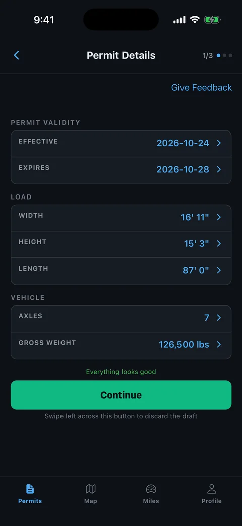
You upload the permit PDF. The app reads the required roads in order, plus the start, end, dimensions, weight and dates. You check each field against the paper and confirm. It then gives turn-by-turn on those roads and warns you if you leave them. RouteAll does this for any state's permit.
- Upload the whole PDF as the state issued it. On eligible paid plans you can photograph a printed permit instead.
- Let RouteAll read it. It lists the mandated roads with the start and end points. Nothing is driven yet.
- Check every field against the paper, using the check list further down. Edit anything it read wrong.
- Confirm and drive. Guidance stays on the roads the permit names and warns you the moment you leave them.
One trip joins up to 6 state permits into one route that meets at each state line. A multi-state trip uses an available trip credit or an eligible plan.
The app reads the document; it does not ask the state for the route. A reader can misread a field, which is why your check comes before the drive.
How do you pin a permit route by hand?
Read the permit's route list and drop a pin on each road where the route turns, in the order the permit lists them. The GPS draws a line between the pins. Place them close enough that it cannot pick a different road between two of them. A long, complex permit can run past 100 pins.
Drivers report the strain in a public trucking forum thread from September 2025. One describes a complex job that took 130 to 140 waypoints. Another found entering a 50-mile permit route into a Garmin dēzl frustrating.
Between two pins, the GPS chooses the road. A missing pin at one turn can move the line off the permitted route, and the GPS will not warn you.
In inRoute (iPhone, iPad and Mac)
- Add the start, then each turning point, then the destination, in permit order.
- Stay under the limit: 8 locations on the free version, 150 on inRoute Pro.
- Drive with its voice guidance. Its Agenda Nav option instead hands one leg at a time to Apple Maps, Google Maps or Waze.
- Export a GPX file from the map's Share icon to send the route on. Sharing is a Pro feature.
A leg handed to a car navigation app is routed by that app, so pin those legs tightly.
In a Garmin dēzl OTR
- Open Route Planner: select dēzl, then Route Planner, then Create Route.
- Add each location in the order the permit lists the roads.
- Shape the line: select the saved route, then Shaping, and pick points on the permitted road. A shaping point steers the route without adding a stop.
- Set the truck profile, knowing Garmin's manual says the profile does not guarantee every restriction is accounted for.
In Google Maps
- Add stops in permit order. A route holds up to 9 stops, including the destination.
- Split a longer permit into legs at state lines or major junctions, and start each leg as you reach it.
- Expect car routing. Google says its driving routes are designed for cars and may use car-only roads.
Google My Maps on a computer draws directions on their own layer, up to 10 layers per map. Google's My Maps help does not describe turn-by-turn navigation from it, so treat it as a reference map. Why a car map drifts off a permit is covered in why Google Maps cannot follow your oversize permit.
Can you get the route from the state or your permit service?
Sometimes. ProMiles Permit Route Guidance loads the state's own route for free in Illinois, Indiana, Mississippi, North Dakota and Ohio, with Colorado and New Hampshire testing, as of November 3, 2026. It works with single-trip routed permits only. Elsewhere, ask the permit service that ordered your permit.
ProMiles reads the barcode printed next to "Audible Route Guidance" on the permit, or the permit number. Its page says the app does no routing of its own and does not store the route. You retrieve it each time.
Leave the route and it alerts you, ends route following and tells you to call the permit office. Our guide to following an oversize permit route turn by turn covers that mode in detail.
Texas is different. After TxDMV's April 2025 TxPROS upgrade, the permit PDF includes a QR code that opens the permit's details. Some apps import the Texas route from it, as their own pages describe in our comparison of oversize permit route apps.
Ask your permit service whether it can send a route map or the route itself. A service that works with RouteAll can check the route read from each state's permit and send the trip to your app. The guide on how a permit service sends a permit to your GPS shows that handoff.
What should you check before you drive?
Put the permit next to the screen and compare field by field, whichever way you built the route. These five checks catch the errors that move a load off its permit:
| On the screen | Check it against | Why it matters |
|---|---|---|
| Required roads | The route list on the permit, road by road and in order | One wrong road number moves the line |
| Direction on each road | The direction the permit prints, such as N or W | The right road in the wrong direction is still off route |
| Start and end points | The from and to lines on the permit | A wrong start puts the first mile off route |
| Width, height, length, weight | The load on the trailer | The permit covers only the load it describes |
| Valid dates | The permit's valid-from and valid-to dates | The permit covers only those dates |
The permit is the legal document, not the screen. If the two disagree, the permit wins.
Read the travel conditions on the paper too. Curfews, daylight rules and escort requirements govern the move as much as the roads do.
Can your escort get the same route?
Yes, if the tool can share it. In RouteAll, you send the route by link, and the escort opens it free with no account. An inRoute GPX file needs inRoute on the escort's device. The pilot car route sharing guide covers the escort's side.
Agree before you leave how you will both handle a closed road.
Before you roll
Read the roads on the screen against the roads on the paper, every time. A pin, a state route or an app read only saves typing. If construction blocks a named road, call the permit office before you turn.
Common questions
Is there an app that scans the QR code on a permit?
Yes, in some states. ProMiles Permit Route Guidance scans the barcode on permits from Illinois, Indiana, Mississippi, North Dakota and Ohio. Texas permits carry a QR code that opens the permit on TxPROS, and some apps import the Texas route from it. RouteAll reads the printed roads, so a permit without a code still works.
What does a Missouri route like "Z Jefferson W" mean?
It most likely reads as Route Z in Jefferson County, heading west — MoDOT publishes no key we could find, so call MoDOT’s permit office if a line is unclear. MoDOT assigned its lettered routes county by county, so the same letter can name different roads in different counties, and the permit prints the county. A Missouri permit we examined reads "Continue on A ST. CHARLES E" in the same pattern. If a line is unclear, call MoDOT's permit office before you move.
How do I get an inRoute route into Google My Maps on Windows?
Export it from inRoute as a GPX file: tap the map's Share icon and email it to yourself. Sharing is an inRoute Pro feature. On the Windows computer, open Google My Maps, create a map, choose Add layer, then Import, and select the GPX file. Check what imported against the permit before you send it on.
Can I put a permit route into a Garmin dēzl?
Yes, by hand. Build it in Route Planner, add the locations in permit order, then use Shaping to pull the line onto each permitted road. Garmin's dēzl OTR810 and OTR1010 manual does not describe importing a permit, so you enter the roads yourself.
Can RouteAll read a photo of a paper permit?
Yes, on eligible paid plans. On the free plan you upload the permit as a PDF. Either way, check every field RouteAll read against the permit itself before you drive.
Do I still need to carry the paper permit?
Yes. The permit is the legal document, and officers ask for the permit, not the app. RouteAll reads the permit you provide. It does not issue permits or guarantee compliance, and the driver remains responsible for the load.
How much does it cost to turn a permit into a route?
In RouteAll, one trip a month is free, up to 6 state permits, with no card to start. The free trip is used when you confirm the route. A 3-trip pack is $19.99, and RouteAll Pro is $29.99 a month or $299.99 a year. Printed-permit camera capture is paid. Sharing a route with your escort is free.
Further reading
Sources
- Google Maps Help: multiple destinations — up to 9 stops, including the final destination; routes designed for cars. Checked November 12, 2026.
- Google My Maps Help: import data and layers — GPX import; up to 10 layers. Checked November 12, 2026.
- inRoute on the App Store, inRoute: sharing routes and inRoute: navigating routes — 8 locations free, 150 on Pro; GPX export is a Pro feature; Agenda Nav hand-off. Checked November 12, 2026.
- Garmin dēzl OTR810/OTR1010 owner's manual — Route Planner, shaping points, truck profile. Checked November 12, 2026.
- ProMiles Permit Route Guidance — live and testing states as of November 3, 2026; single-trip permits; no routing or route storage. Checked November 12, 2026.
- TxDMV bulletin, April 11, 2025 — TxPROS permit PDFs include a QR code that opens the permit details.
- MoDOT blog, August 16, 2012 — lettered routes were assigned county by county.
- TheTruckersReport forum, "Over sized route gps," September 2025 — drivers describe pin counts and manual entry.
RouteAll reads the permit you provide. It does not issue permits or guarantee compliance. The driver remains responsible for the load. Features and prices change; verify against the permit and the issuing state before every move.