 RouteAll
Oversize load route planner: watch a permit become a route
This is a real Texas oversize permit for a building moved from the Houston area to Texarkana. Press the button to see what RouteAll reads from it and the route it builds. The sample was read in advance, so nothing is uploaded.
-
1The permit
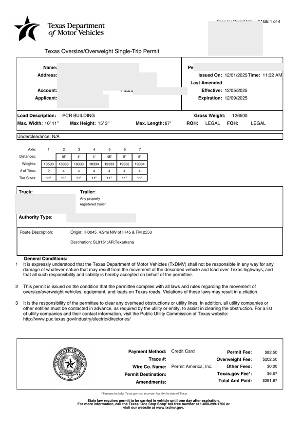
Carrier details redacted, load data untouched. Open the PDF -
2What RouteAll read
- Load
- PCR Building
- Max width
- 16′ 11″
- Max height
- 15′ 3″
- Max length
- 87′
- Gross weight
- 126,500 lb
- Axles
- 7
- Valid
- Dec 5 – Dec 9, 2025
- Issuing state
- Texas (TxDMV)
Every value comes from the permit above. Drivers check each one against their permit before they drive; across real permits so far, 85% needed no edits.
-
3The 13 road sections it names, in order
- IH 45
- SL 8
- IH 69
- US 59
- FM 62
- US 287
- US 69
- FM 1669
- SH 103
- SH 147
- US 96
- US 59
- SL 151
From IH 45, 4.9 mi NW of IH 45 & FM 2553, to SL 151, Texarkana. About 391 miles.
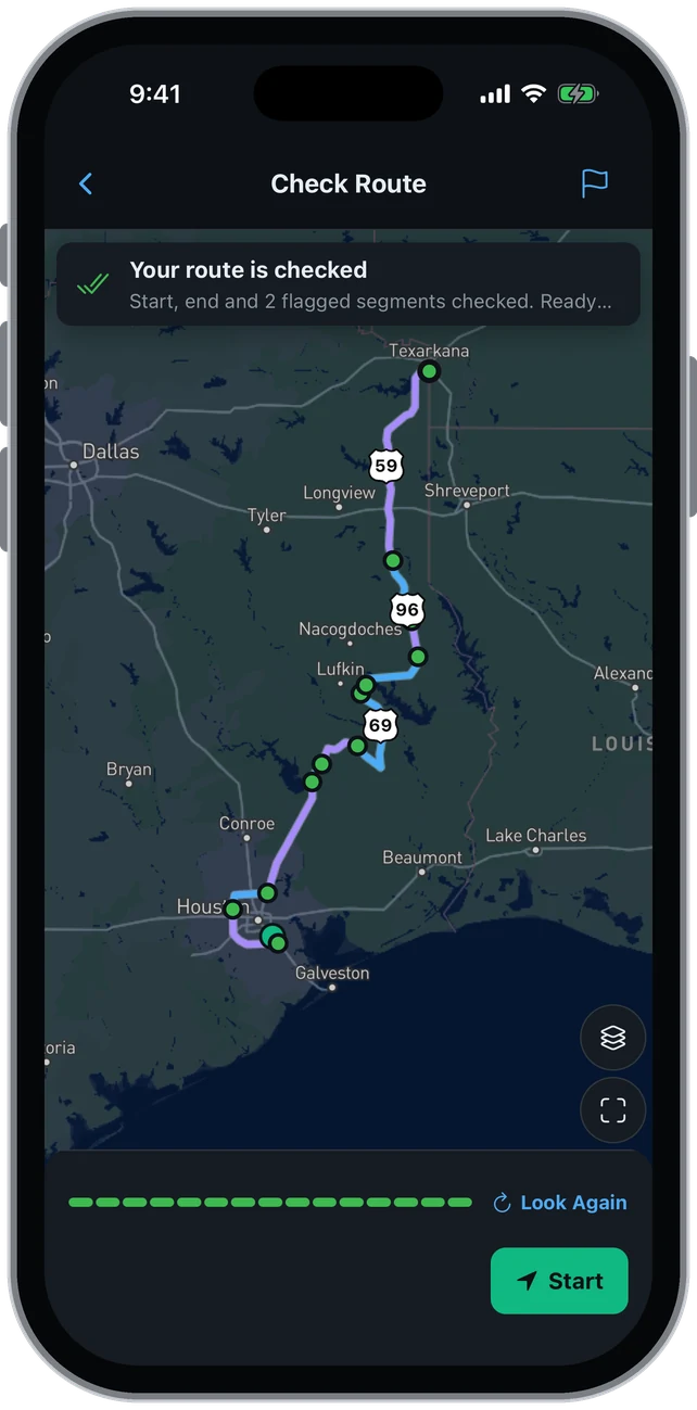
The route drawn on only the roads the permit names, every section checked. -
4Check each road, then drive
Before you drive, RouteAll walks you through the route one section at a time. A section that doesn't match the permit, by road or by miles, is flagged so you can fix it on the map. Then turn-by-turn directions stay on the permitted roads; RouteAll never reroutes you off your permit the way Google Maps does.
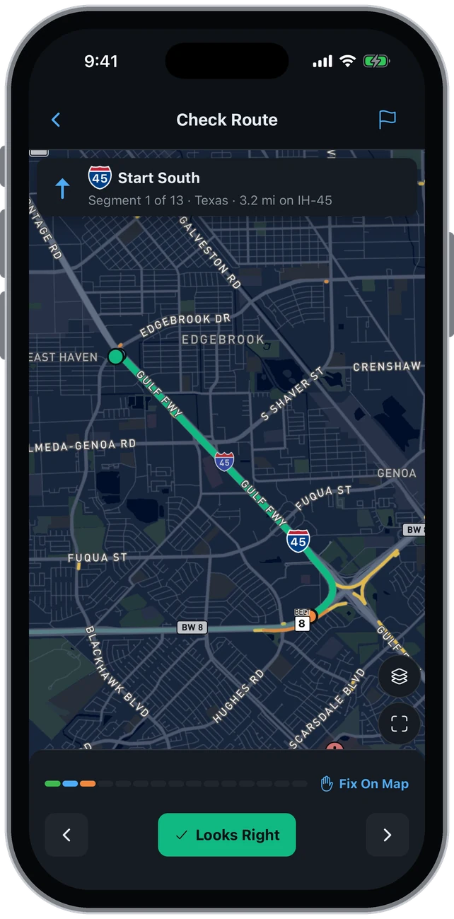
Each section names its road and miles: 3.2 mi on IH 45 to Beltway 8. 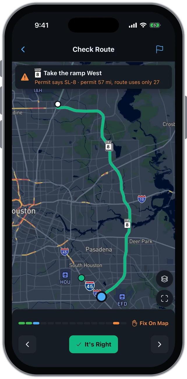
Flagged: the permit says SL 8 west for 57 mi; this draft took the 27-mi east side. Fix it on the map. -
5Now try your own permit
One free trip every month, up to 6 state permits. No card to start. Reading a permit doesn't use the trip; confirming the route does.
Get RouteAll Free★ 4.8 on the App Store · 170+ permits read from 33 states.



Route planner or truck GPS?
A truck GPS, or Google Maps, starts from an address and works out its own path. Your permit already chose the path: it is a list of roads the state checked for your load, in order. An oversize load route planner reads that list and stays on it.
- Where the route comes from
- Truck GPS: a routing engine, from your destination. RouteAll: the roads printed on your permit.
- You miss a turn
- Truck GPS: a new path to the same address. RouteAll: a warning that you left the permitted route.
- Traffic ahead
- Truck GPS: looks for a faster way around. RouteAll: stays on the roads the permit names.
- Low bridges, weight limits
- Truck GPS: its own truck road data. RouteAll: roads the state checked for your load.
- The pilot car needs the route
- Truck GPS: a screenshot or a dropped pin. RouteAll: the permitted route, shared by link, free to open.
A warning beats a reroute because no app can add a road to your permit. In most states, leaving the named roads leaves you outside the permit. Florida caps dimension and safety-condition penalties at $1,000 per vehicle, charges weight violations per pound and voids the permit when a special condition is broken (s. 316.550). Louisiana fines $100 per permit-condition violation (RS 32:388).
What to look for in one
- Route source: the permit document, not a destination pin.
- Check screen: every field next to the permit's own words before you drive.
- Off-route warning: loud and immediate, not a silent new line.
- Escort access: the pilot car opens the route free, with no account.
- Multi-state: one route across every state the load crosses.
Can I use Google Maps for an oversize load?
Not to follow the permit. Google Maps routes to an address and picks its own roads. Your permit names the roads you are authorized to use. A map app is still fine for finding fuel or parking, but drive the roads on the permit.
Does a truck GPS know my oversize permit route?
No. A truck GPS knows your rig's size and its own road data, but it has never seen your permit. It computes a path to your destination. That path may or may not match the roads the state named, and the GPS cannot tell you which.
What happens if I miss a turn in RouteAll?
RouteAll warns you that you have left the permitted route. Get back on it the way the permit and the state allow. If you cannot, stop where it is safe and call the permit office. RouteAll does not issue permits or guarantee compliance.
Questions drivers ask
- Why can't Google Maps follow my permit?
- How do I turn a PDF permit into a GPS route?
- How do I plan a multi-state oversize permit route?
- What does RouteAll cost?
RouteAll reads the permit you hold. It does not issue permits, choose a legal route or guarantee compliance.